 |
|
Below each map you will find links that lets you move to the map segment north, east, south or west of the one you are looking at (naturally, not all choices are available for all maps). If you prefer to "walk through" the maps one by one, you can do this by choosing the first map (number 1) and use the next-link provided below each map. The spelling of names of farmes and places have changed considerably throughout history. So if you are looking for an ancestral name from the last century, chances are that the spelling will be different today. Also be aware that some names are used several places in Øyer. |
|
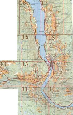
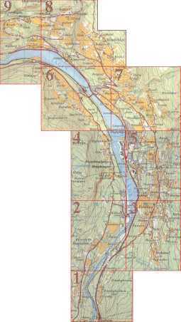
Welcome to The Øyer Maps. The map to the right and below shows Øyer from the border towards Ringebu in the north, to Lillehammer in the south. The map is divided into segments numbered from 1 (in the south) to 18. Each segment is clickable and will take you to a much more detailed map, one for each segment. It is also possible to use the number list at the bottom of this page to open the maps, which are around 40KB each. The map segments are detailed to a degree where most farms and places in Øyer are shown. If you are looking for a spesific name and your browser support frames, you can use the Searchable Farm Index. |
|
Choose map (or click on image above):
![]()
![]()
![]()
![]()
![]()
![]()
![]()
![]()
![]()
![]()
![]()
![]()
![]()
![]()
![]()
![]()
![]()
![]()
Back to Kaldor Farm Homepage